


Tauerbrenner 2011
| Tour plan | 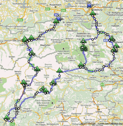 |
| Distance | 780/830 km |
| Duration | 9 days |
| Elevation profile | The outward journey in particular is very mountainous with long climbs and four passes over 2,000 metres, and on the return journey the Brenner Pass is the biggest challenge at around 1,400 metres. |
| Surface | The roads and cycle paths are in very good condition throughout, but not all separate cycle paths are usable in bad weather. |
| Traffic | There is tourist traffic on the high alpine roads, otherwise parallel cycle paths are available on all busy roads in Austria and Italy. |
| Difficulty (1..easy 6..difficult) |
5 |
| Last tried out | 25.06.-03.07.2011 |
Our Route Planning
Prologue - From Freilassing to Au (20 km)
Freilassing - (border) - Salzburg - [159] - Au
Stage 1 - From Au to Fusch a.d.G. (95 km)
Au - [159] - Hallein - [159] - Golling a.d.S. - [159] - Werfen - [159] - Bischofshofen - [311] St. Johann i.P. - [311] - Schwarzach i.P. - [311] - Bruck a.d.G. - [107] - Fusch a.d.G.
Stage 2 - From Fusch a.d.G. to Lienz/Amlach (85 km)
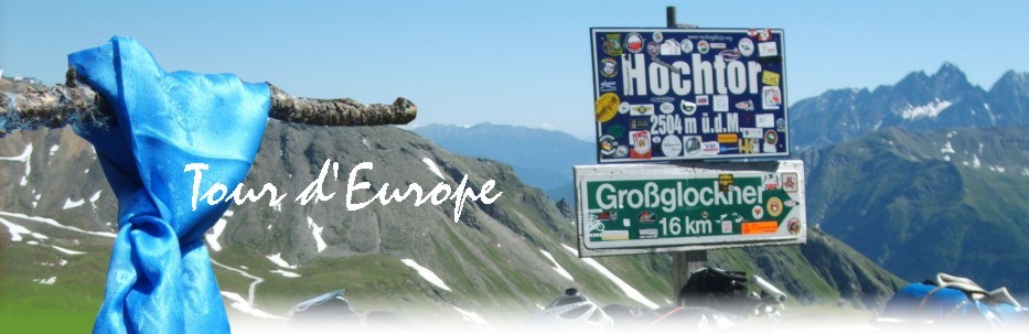
Fusch a.d.G. - [107] - Fuscher Törl (2428m) - [107] - Hochtor (2504m) - [107] - Heiligenblut - [107] - Mörtschach - [107] - Winklern - [107] - Lienz - Amlach
Stage 3 - From Lienz/Amlach to Vallada Agordino (140 km)
Amlach - [100] - Mittewald - [100] - Silian - (border) - [SS49] - San Candido - [SS49] - Dobbiaco - [SS51] - Landro - [SS51] - Carbonin - [SS51] - Cortina d'Ampezzo - [SR48] - Pocol - [SP638] - Passo Giau (2236m) - [SP638] - Selva di Cadore - [SP20] - Caprile - [SR203] - Alleghe - [SR203] - Cencenighe Agordino - [SP346] - Vallada Agordino
Stage 4 - From Vallada Agordino to Nago-Torbole (150 km)
Vallada Agordino - [SP346] - Falcade - [SP346] - Passo San Pellegrino (1918m) - [SP346] - Moena - [SS48] - Predazzo - [SP232] - Castello-Molina di Fiemme - [SP71] - Valfloriana - [SP71] - Sover - [SP71] - Segonzano - [SP71] - Civezzano - Trento - Mattarello - Acquaviva - Calliano - [SS12] - Rovereto - [SS240] - Mori - [SS240] - Nago-Torbole
Stage 5 - From Nago-Torbole to Bolzano (105 km)
Nago-Torbole - Riva del Garda - Arco - [SS45bis] - Dro - [SS45bis] - Padergnone - [SS45bis] - Trento - "Via Bolzano" - Lavis - [SS12] - San Michele all'Adige - [SS12] - Salorno - [SS12] - Egna - [SS12] - Ora - [SS12] - Bronzolo - [SS12] - Pineta - San Giacomo - Bolzano/San Maurizio
Alternativ From Trento to Bolzano: [Adige-Cycleroute]
Stage 6 - From Bolzano to Hall i.T. (145 km)
San Maurizio - Bolzano - Comedo All'isarco - [SS12] - Blumau - [SS12] - Ponte Gardena - [SS12] - Chiusa - [SS12] - Bressanone - [SS12] - Varna - [SS12] - Fortezza - [SS12] - Campo di Trens - [SS12] - Vipiteno - [SS12] - Brennero - [SS12] - Passo del Brennero (1374m, border) - [182] - Steito a.B. - [182] - Matrei a.B. - [182] - Schönberg i.S. - [182] - Natters - [182] - Innsbruck - [171]/[Inn-Cycleroute] - Hall i.T.
Stage 7 - From Hall i.T. to Unterlangkampfen (75 km)
Hall i.T. - [171] - Wattens - [171] - Schwaz - [171] - Strass i.Z. - [171] - Brixlegg - [171] - Wörgl - [171] - Kirchbichl - Unterlangkampfen
Epilog - From Unterlangkampfen to Kiefersfelden (10 km)
Unterlangkampfen - Kufstein - [171] - (border) - Kiefersfelden
Overnight Stays
Prologue - From Freilassing to Au (20 km)
Name: Camping Auwirt
Kat. *** - Capacity 50 - open 06.04.-15.10.
Address: Salzburger Straße 42
Postcode/place: 5400 Hallein/Au
Area: Österreich
Tel: +43-(0)6245-80417
Fax: +43-(0)6245-84635
www.auwirt.com
GPS: N 47°42'16" E 13°4'7"
Altitude: 400m
Stage 1 - From Au to Fusch a.d.G. (95 km)
Name: Camping Lampenhäusl
Capacity 50 - open 10.05.-25.10.
Address: Großglocknerstraße 15
Postcode/place: 5672 Fusch a.G.
Area: Österreich
Tel: +43-(0)6546-2150
Fax: +43-(0)6546-215302
www.lampenhaeusl.at
GPS: N 47°13'28" E 12°49'36"
Altitude: 887m
Stage 2 - From Fusch a.d.G. to Lienz/Amlach (85 km)
Name: Dolomiten Camping Amlacherhof
Kat. **** - Capacity 83 - open 15.04.-15.10.
Address: Amlach 5
Postcode/place: 9900 Lienz/Amlach
Area: Österreich
Tel: +43-(0)4852-62317
Fax: +43-(0)4852-6231712
www.amlacherhof.at
GPS: N 46°48'48" E 12°45'47"
Altitude: 710m
Stage 3 - From Lienz/Amlach to Vallada Agordino (140 km)
Name: Camping Lastei
Kat. **
Address: Pian De Sabion
Postcode/place: 32020 Canale d'agordo
Area: Italien
www.campinglastei.it
Stage 4 - From Vallada Agordino to Nago-Torbole (150 km)
Name: Campeggio Europa
Kat. **
Address: Via al Cor 4/21
Postcode/place: 38069 Torbole
Area: Italien
Tel: +39 0464-505888
Fax: +39 0464-549879
GPS: N 45°52'21" E 10°52'18"
Altitude: 70m
Stage 5 - From Nago-Torbole to Bolzano (105 km)
Name: Camping Moosbauer
Kat. **** - Capacity 100 - open 01.01.-31.12.
Address: Moritzinger Weg 83
Postcode/place: 39100 Bozen
Area: Italien
Tel: +39 0471 918492
Fax: +39 0471 204894
www.moosbauer.com
GPS: N 46°30'13" E 11°17'59"
Altitude: 259m
Stage 6 - From Bolzano to Hall i.T. (145 km)
Name: Ferienparadies Natterer See
Capacity 235 - open 26.04.-01.11.
Address: Natterer See 1
Postcode/place: 6161 Natters
Area: Österreich
Tel: +43-(0)512-546732
Fax: +43-(0)512-54673216
www.natterersee.com
Stage 7 - From Hall i.T. to Unterlangkampfen (75 km)
Name: Parkcamping Hager
Capacity 35 - open 01.01.-31.12.
Address: Kufsteiner Straße 38
Postcode/place: 6336 Langkampfen
Area: Österreich
Tel: +43-(0)5372-64170
Fax: +43-(0)5332-7296635
GPS: N 47°33'57" E 12°7'35"
Altitude: 500m